Automatic Monitoring System for Area Precipitation
- DESCRIPTION
- TECHNICAL
- SPECIFICATIONS
Probecom cooperates with famous Chinese insitutes and famous universities to developt meteorological radar products. Product list include stratospheric wind profiler radar, S band dual Polarization weather radar, C band dual polarization full coherent weather radar, boudray layer wind profiler radar, low-level wind profiler radar, low level wind shear alert system, troposheric wind profiler radar, mobile millimeter wave weather radar system, clound & Fog detection and prediction system, comprehensive meteorological system.
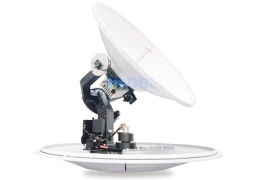
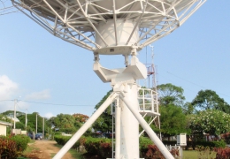
The automatic monitoring system for area precipitation, divided into two types PRS-11 and PRS-11/M, is a precipitation monitoring system with high time-space resolution and continuous space. With its international advanced technology, this system can be widely applied in the monitoring of rainfall, rainfall intensity, raindrop spectrum of small and medium-sized river flood, mountain disasters, urban waterlogging, highway, railway, aviation and power transmission lines, regional water quality, water resources, etc.
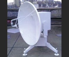
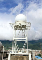
Function and Feature of PRS一11 System
*High time-space resolution: The rainfall measuring station outputs 10s step length of particle-size spectrum and velocity spectrum every 5 minutes. The field monitoring station outputs the area precipitation field of 90*90㎡
*spatial resolution, better than the current 500*500㎡ international level.
*Seamless area precipitation: Based on the high time-space resolution, it is able to realize continuous spatial coverage within 36km radius area (about 4000 k㎡) and improve the representativeness of precipitation measurement.
*Optimal elevation scanning: The antenna of precipitation radar can be set to an optimal variable scanning elevation in accordance with surrounding buildings and terrain to reduce the influence caused by the city buildings and complex mountainous area terrain.
*Vertical scanning: The information captured by the precipitation radarperforming vertical scanning and the spectrum data measured by disdropmeter will be sent to attenuation model in terminal system, which compensates shortage of X-band radar in attenuation.
*Unmanned operation: Abundant control and analysis application software such as automatic alarming and automatic monitoring provides a guarantee for system automatically continuous operation and automatic precipitation field measurement.
*High cost performance ratio: Real time attenuation correction and dynamic mathematical physical model improve the quantitative measurement ability of the system area precipitation. Scientific design brings some advantages to this system like high reliability and low construction, operation and maintenance cost.
*Wide application:The system is suitable for water conservancy, transportation, agriculture, military, electric power, energy, meteorology, oceans and scientific research departments to perform emergency/disaster rescue and public security service.
Automatic Monitoring System for Area Precipitation
The automatic monitoring system for area precipitation, divided into two types PRS-11 and PRS-11/M, is a precipitation monitoring system with high time-space resolution and continuous space. With its international advanced technology, this system can be widely applied in the monitoring of rainfall, rainfall intensity, raindrop spectrum of small and medium-sized river flood, mountain disasters, urban waterlogging, highway, railway, aviation and power transmission lines, regional water quality, water resources, etc.
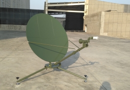
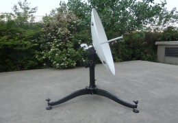
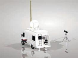
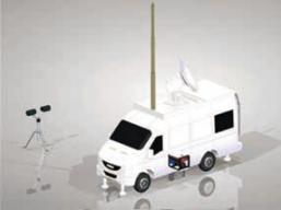
Function and Feature of PRS11/M System
*Good mobility and cross-country ability.
*Fast and easy setup and tear-down.
*Automatic leveling and north-finding.
*The precipitation monitoring radar adopts IF coherent pulse Doppler system, which has high cost effective performance and low life cycle cost.
*The laser disdropmeter in this system can provide multiple parameters.
*Able to provide real time precipitation accumulation and hourly precipitation within detection area, and update the one-hour, three-hour and six-hour area precipitation every 5 minutes.
*Able to provide the detection data from precipitation monitoring radar subsystem, for instance, the image distribution information of raw products, such as weather echo intensity, the average radial velocity and velocity spectrum width.
*Able to provide the detection data of disdropmeter subsystem and the real time data of precipitation particle diameter, particle velocity, radar reflectivity and rainfall intensity.
*Able to connect to other systems via Ethernet fast and safely like hydrological database, send hydrological data to other computer, and integrate with other hydrological detection system equipments.
*The system is equipped with automatic calibration device for spatial location.
*The system can initialize and recover the operation parameters automatically after being reset.